Got a very nice email from a former military pilot, now an airline captain, who’d read some things I’d written about aviation. He had this travel tip. I wonder if anyone else has seen it. Here goes:
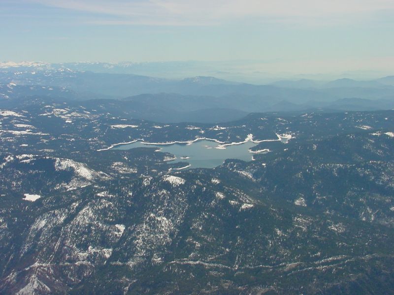
I wanted to pass on to you a great canyon you would just love to take your Cirrus down. The canyon is just West of the Mammooth Mtn ski area and starts on the Friant FRA 015radial at about 30 nm. The canyon descends West and is wide with water falls on both sides, its spectacular. It also has a rock outcrop that looks like a small half dome. It is an awesome ride and your Cirrus will have plenty of performance. Also the terrian descends the whole way down with no boxed canyons so its a safe ride. If you ever head south from the bay area it would be worth the detour. Let me know if you are  interested in any more details. Fly safe.<<
In a mountain flying class we plotted a course to Mammoth Mtn using the 023 radial V230 which starts at the VOR in the valley and leads the way to the other side of the mountains and Mammoth airport. I have always wanted to fly this route coming back across at Truckee. Now I have an additional incentive, when the weather is better.
Jim:
I’ve flown this route many times heading from the coast to the Eastern Sierras, but always at altitude. It is indeed a gorgeous area.
I’m sure this flight would indeed be spectacular and normally within the reasonable operating range of a SR22, under appropriate weather conditions and with a pilot trained in mountain flying. At the wrong time of day and/or with strong winds aloft, there can be significant downdrafts/turbulence on the eastern slope of the Sierras, far greater than the SR22’s ability to climb out.
I think an important thing for someone to consider before flying this route at any altitude, but especially down low, is the sheer ruggedness and complete lack of roads and habitation. You certainly won’t be gliding to a safe, flat landing area for 20 or 30 miles of the route if you have trouble. Once you are over the ridge (eastbound), the eastern side is much more open and gliding all the way to MMH is a possibility if you keep up high.
The FAR/AIM admonition to operate only where a safe landing can be made in case of a problem is obviously not something that we all do all the time. In most real-world mountain flying in rugged areas, canyons or valleys it should be clear to most pilots that an engine failure is a life-threatening event - you aren’t going to put it down in Farmer Jones field. It is also difficult or impossible to receive flight following at anything lower than the very high MEA on the airway (~14,000 ft. by memory) - I am inevitably dropped with ‘radar contact lost’ even above 12,000 ft. on the airway, so there’s no one there to notice if you never arrive on the other side, and they sure won’t know where to look for you. Even if you do land safely or survive a CAPS descent, survival will be a serious issue - this is real wilderness. I won’t fly this route without my 30 lb. survival kit including several gallons of water.
For pilots who don’t feel comfortable with the tradeoffs involved here, and who want to stay higher above the terrain, I think crossing the Sierras along the I-80 corridor west of Reno and north of Lake Tahoe provides equally spectacular scenery and the opportunity to land off-airport near/on a major highway or in a lot more comparitively flat emergency landing spots (or actual airports) than you’ll find west of Mammoth.
Now that I’m sounding like Chicken Little, I will say that making this sort of risk vs. reward decision is part of why we fly, and for the well informed and well prepared pilot, the flight suggested is in a drop-dead gorgeous region…on the eastern side the terrain between Mammoth and Mono Lake is as bizzare and beautiful as I would imagine a flight on Mars…I also suggest flying north to Bridgeport Bryant field and walking 1/4 mile into town for lunch or whatever.
I flew this canyon in March last year. It is indeed spectacular, and performance two-up in an SR20 was not a problem. We had flown from Sedona to Mammoth Lakes then went down the canyon a ways then north to Napa. Winds over the Sierras were about 20 knots and produced no significant turbulence. The Mammoth Lakes airport is worth a visit itself - lovely FBO with a log fire burning.
The first pic below is the terrain to the north of the pass opposite the ski resort, and the second is a beautiful mountain lake on the southern side of the valley.
I have made the trip from San Diego to Mamouth a few times in both the spring and winter. I must say the trip up the Owens valley on the way back has always been a rough flight but the SR 22 did very well. I agree that I would not have gone east or west over the mountains and I tend to go up the high desert and on one side or the other of the valley. You can get some real cross winds at the airport and must use caution on departure.
I understand from your earlier posts that GPIRB is currently intended for nautical use and not yet approved for aviation use…my question is, when you are sitting on the ground up there in the mountains at 10,000 feet, how does the Coast Guard get the rescue boat up there to pick you up? [;)]
Seriously, do you know how the folks who receive the distress signal respond when the target is obviously not nautical?
I don’t know what the statistics are, but I wonder if this sort of functionality, even though expensive, might be a lot more likely to come in handy some day than, say, the backup gyro or ‘GPS gyro’ discussed a while back.
I understand from your earlier posts that GPIRB is currently intended for nautical use and not yet approved for aviation use…my question is, when you are sitting on the ground up there in the mountains at 10,000 feet, how does the Coast Guard get the rescue boat up there to pick you up?
Actually GPIRB’s have now been approved for use throughout the US, and are now known as Personal Locator Beacons (PLB’s). The announcementEquipped to Survive site.
Seriously, do you know how the folks who receive the distress signal respond when the target is obviously not nautical?
COPAS-SARSATditch bag” along with my survival kit. The one I have is the http://www.nat-inc.com/gpirb2/gpirb2.htmNAT GPIRB II model S-1525. You want the manual model 1525, NOT the automatic model 1520. Here is a source that has it for $1,073. I contend that it is the best bang for the buck you can spend on safety equipment.
More SARSAT stuff:
COSPAS/SARSAT are satellite systems that work as one. SARSAT - operated by Canada, France and the United States - stands for Search And Rescue Satellite-Aided Tracking. COSPAS, operated by Russia, performs the equivalent function.
COSPAS/SARSAT satellites are always listening for distress calls from Earth. It’s their job to receive signals from emergency radio beacons and return them to Earth so help can be sent. That’s why it is so important for beacons to be carried on an aircraft, boats, on land and on your person particularly in isolated areas. That way, the system can do its job if you get into trouble.
COSPAS/SARSAT satellites circle the Earth in polar orbit about every 100 minutes, thus ensuring that signals can be received frequently. They are able to receive signals from EPIRBs and relay them to ground stations known as Local User Terminals (LUTs). The LUTS relay this information to search and rescue authorities where the location of the beacon is determined.
The EPIRB’s position can generally be calculated to within 20 kms. [NOTE: With a GPIRB, this is about 30 feet!] From there, rescue vessels or aircraft are despatched with tracking equipment to quickly home in on the beacons signal.
Local User terminals (LUTs) are now located strategically throughout most of the world. In Oceania, LUTs are operational in Bundaberg (Queensland), Albany (Western Australia), Wellington (New Zealand), Indonesia and Singapore.