ATC: \"say heading\"

In reply to:


Very true, but I donÂ’t have much trouble flying a track using my GPS readout.
Anyway, that’s how this whole thread started. We were discussing why panel mount GPSÂ’s donÂ’t have HSIÂ’s and decided itÂ’s because they would have to show heading, not track, and since all a GPS knows is track it wouldnÂ’t be legal. So the question at hand is should the ATC system hang on to the past, or accommodate a move toward the future?


Joe,
Not true. THIS thread is in response to the question of what to tell the controller when he asks you to “say heading”.
Obviously the answer is contained in the question.
There was a different thread dealing with the issue of why Garmin can’t put a HSI (like in their hand helds) on the 430.

In reply to:


Not true. THIS thread is in response to the question of what to tell the controller when he asks you to "say heading"Â… There was a different thread dealing with the issue of why Garmin can’t put a HSI (like in their hand helds) on the 430.


Ah. Yes.

But… I think if you trace the ancestry of the current thread through all the thread-splitting youÂ’ll find it does indeed relate to the HSI post. (But then, thatÂ’d be splitting hairs, wouldnÂ’t it?)

In reply to:


Obviously the answer is contained in the question.


One would think so, wouldn’t one?

Anyway, let’s say I’m flying along minding my own business and I get the call: “Cirrus 1360C - say heading”

First of all, the proper response is obvious. Then, the question comes up: “I wonder why he asked?”

In my experience, it’s one of two things:

  1. A subtle reminder that maybe I’ve let my heading drift or that I’m possibly headed in a different direction than he had expected, or,

  2. He’s getting ready to turn me x degrees right or left and needs the heading to compute the new desired heading.

Often, they’ll just say something like, “turn 20º left, I’ll have on course for you in x miles”.

OTOH, when they ask for “on course heading” they just want to know about what direction I’m headed - for instance Jax Approach may have absolutely NO idea where the Harris VOR is. An answer of “about 320º” has never required clarification or a request for more precision.

Your question, “… should the ATC system hang on to the past, or accommodate a move toward the future?” presumes that navigation solely by gps track is a move to the future. It isn’t necessarily so. It’s a great way to go direct from point A to point B, but a bad way to fly under ATC radar control. Granted. GPS represents a big step forward in the cockpit, but it has little use in the radar room.

All the built in inaccuracies of radar, eg to extent affected by weather, inaccurate distance calculations, improper alignment of screens with lat/long, variations between different radar screens tend to be self-cancelling errors when the primary mission is traffic separation, since the same error would exist for all traffic on the screen. Correcting these errors to the same precision of a GPS would be a hopeless task.

Something similar might be accomplished if every plane continuously transmitted its GPS coordinates to the ATC, which relied solely on these broadcasts and not radar. As for me, I much prefer the integrity of a single ground-based radar, over the integrity of individual plane transmissions.

Heard of http://www.alaska.faa.gov/capstone/faq.htm>ADS-B?East Coast

I think we should be more open to exploring the future rather than hanging on to the past. Sure, the old system works, but with the limitations you outline. At the risk of using an overused buzzword, the use-GPS-instead-of-radar idea you mentioned is called a paradigm change. Once you make it, whole new worlds open up. My guess is it would be much cheaper and more effective to have the FAA buy and issue to every pilot an autonomous GPS beacon than to build and maintain large complex radar systems, subject to all the limitations you outlined, and which have a much higher failure rate than GPS.

Yup, I have heard of capstone, but not followed it too closely. The problem with relying SOLELY on this type system for traffic separation is that there must be a perfectly functioning unit in every plane…ie, I don’t think it’s a replacement for radar, as much as a tool for pilots. What does a controller do when a 747 departing JFK, and in the clouds, suddenly “disappears” from his screen, because some little wire shorted out in the airplane? A Cessna 152 that disappears could be just as dangerous. I think they would always have to have some form of ground based radar that works independently of what’s in the plane. Even a primary radar signal (non-transponder based) is of great value, compared to no image.

In reply to:


I think we should be more open to exploring the future rather than hanging on to the past. Sure, the old system works, but with the limitations you outline. At the risk of using an overused buzzword, the use-GPS-instead-of-radar idea you mentioned is called a paradigm change. Once you make it, whole new worlds open up. My guess is it would be much cheaper and more effective to have the FAA buy and issue to every pilot an autonomous GPS beacon than to build and maintain large complex radar systems, subject to all the limitations you outlined, and which have a much higher failure rate than GPS.


Jim,

You’ve touched on one of my favorite subjects. There is often a “better mousetrap” to be had for the asking. Unfortunately it always has a price tag attached to it. And that’s not even half the cost.

The cost to redesign the National Airspace System is astronomical. Just in equipment alone. And I don’t think the equipment is what is really expensive. It’s training all the people.

Let’s say we’re going to make GPS the primary navigation equipment and replace all the VORs. Sounds great up front. GPS is cheap. (Well it seems cheap but only because the DOD has already paid for it.) VORs are expensive.

First, you have to equip the fleet. How long will that take ? You know AOPA and EAA will have something to say about it. Remember how we drug out the 360 channel radio replacement ? That will be years the FAA will have to fund both systems.

Then we have to redo all the charts. Not just every single approach to every airport in the country but all the airways too. You’d have to draw up the technical definitions for “GPS airways” too. Then you’d have to change every single piece of paper in the FAA. From charts to the FARs.

Now what’s your back up for GPS ? It’s really easy to jam a GPS signal. What’s the plan ?

Somebody mentioned replacing radar. And somebody else astutely pointed out that there needed to be a backup for that too. What I didn’t see was, what about the guys that don’t want to be seen ? Remember 9/11 ? They all turned their transponders off. They weren’t the first to think of that.

My point is that what’s possible and what’s “doable” are two different things. If you ever hear the words “revolutionize” and “ATC” in the same breath you’d best grab onto your wallet. It simply isn’t affordable. Nor is it desirable.

The NAS needs to be a stable system. We don’t want the “latest-greatest” technology (with all the bugs in it) we want good, stable technology (with all the bugs worked out.)

The NAS must evolve. Slowly. Methodically. And it does. There are simply too many players (FAA, pilots, controllers, airlines, DOD, law enforcement, etc… etc.) and the costs are too great for it to do otherwise.
Your argument would be more persuasive if radars never failed. Any system can fail; the real question is which system will fail less often and more gracefully.
Having an individual beacon fail would be bad (though transponders fail all the time and skin-paint is a very poor substitue even when available). But there is also a well established track record of total radar failures, and in that case all the planes are wandering around invisible – not just one!

Don’t forget that the capstone system also relies on ground based receivers, the failure of which would cause as many planes to disappear as a radar failure…this point of failure is in addition to the thousands of other lesser points of failure that would exist in every cockpit of every plane in the air.

Don’t get me wrong…I’m no luddite. I greatly support this technology…I just think there’s a long way to go before ATC starts issuing headings based on ground track instead of the heading indicator.

I think the most valuable and practical aspect of a GPS-based, position reporting transponder would be in the area of onboard traffic avoidance systems.

In reply to:


Don’t forget that the capstone system also relies on ground based receivers, the failure of which would cause as many planes to disappear as a radar failure…this point of failure is in addition to the thousands of other lesser points of failure that would exist in every cockpit of every plane in the air.


Agreed. Just as it is now.

In reply to:


Don’t get me wrong…I’m no luddite. I greatly support this technology…I just think there’s a long way to go before ATC starts issuing headings based on ground track instead of the heading indicator.


No argument there!

In reply to:


I think the most valuable and practical aspect of a GPS-based, position reporting transponder would be in the area of onboard traffic avoidance systems.


I do too, at least for the near term.

Ed,
I agree completely.

In reply to:


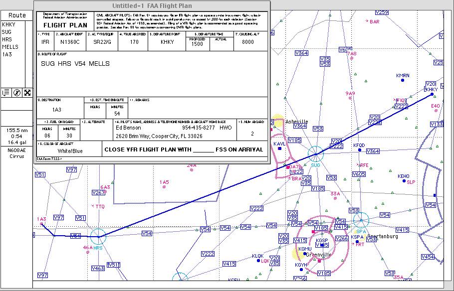
  1. Plan and write out an AIM compliant, IFR flight plan from HKY to 1A3.

I’ll bite:

The final leg (MELLS-1A3) is off-airways with mountains around. I get taken down to 5,600’, from which I either see the airport (elevation about 1,800’) or proceed to my alternate (which I see I forgot to file - always required when destination airport has no instrument approach).

Open to any and all criticism/input. I’ve found that how to file IFR routes is almost a “black art” and seems to differ in different sections of the country.

If I just file “Direct” I often get “cleared as filed”. Wonderful, except on longer flights there’s almost always that eventual “we have an amendment to your routing - advise when ready to copy”. Not a big deal, but I find things easier if I can anticipate the routing ahead of time.

For those still reading this thread…

http://www.avweb.com/news/columns/189197-1.html

Don Brown
NATCA_ZTL Safety Rep.

In reply to:


  1. Plan and write out an AIM compliant, IFR flight plan from HKY to 1A3.

Here’s how I would file the route of flight it using GPS direct…

SUG360008 SOT180026 HRS330011

The nice thing is that DUATS does it automagically for you.

Don,
I never said it’d be easy!
I agree that everything you say is dead on, but each of the obstacles you mention can be overcome. For example, the FAA isn’t in the air defense business so, unless you want to be, why not let the DOD worry about that? (For example, they could have the same display as you do over at NORAD and use their own radar to detect uncorrelated targets.)
The only question is having the political will (and clout!) and, of course, as you persuasively point out, the money.
Finally, these atavistic arguments would be much more compelling if the current system worked better. Equipment failures aside, with millions and millions of cubic miles of airspace out there the current system insists that we all fly over the same few choke points. Does that make sense?

BTW, I really enjoy your articles on AVweb and have learned a lot from them.

Joe

In reply to:


For example, the FAA isn’t in the air defense business…


Oh, but it is. The latest-greatest radars are all found along the US borders. Supplied by the DOD and operated jointly by FAA/DOD.

Check out:

http://www.faa.gov/atpubs/ATC/Chp9/atc0903.html#9-3-8

It’s the same with weather radar. NEXRAD (the latest-greatest wx product) is supplied by the NWS. The product was designed for public safety, not air traffic control. Hence the sites are near major population centers and not always near busy airways.

If the FAA had to pay for all these system for their exclusive use we’d be “broker” than we already are.

In reply to:


Finally, these atavistic arguments would be much more compelling if the current system worked better.


The system would work a lot better if everybody would stick to using it as it was designed to be used. IOW, if they’d stick to the book.

In reply to:


Equipment failures aside, with millions and millions of cubic miles of airspace out there the current system insists that we all fly over the same few choke points. Does that make sense?


Yes, from an air traffic control point it does make sense.

In reply to:


BTW, I really enjoy your articles on AVweb and have learned a lot from them.
Joe


Thanks Joe. It’s kind of you to say so.

Don Brown
NATCA_ZTL Safety Rep.

Don,

Everything you say is true, but just because it’s true now, does that mean it will necessarily always be true? (Remember all those arguments about how the 747 would fail because the infrastructure couldn’t support it?)

Let’s turn those fancy phased array radars looking for incoming Soviet ICBM’s around so they can look south (or install new ones – I know the current ones can’t simply be turned around). They face north for the old paradigm. A new paradigm requires a new reaction.

Sure, choke points make sense for a controller in the current system. That’s the problem! But try to imagine a new ATC paradigm in a new freeform system. Sure, it might be hard getting there, but look at the payoff!

I readily admit that, especially with the government, technological change is difficult. (Look at the FBI’s new computer system!) But I don’t think being fatalistic will help much.

Can we at least agree that improvements are needed, even if you feel they are unlikely?

Joe

In reply to:


Can we at least agree that improvements are needed, even if you feel they are unlikely?
Joe


Improvements will happen Joe. You can’t believe the changes I’ve seen in my career. They just don’t happen as fast as folks would like for them to happen. Sometimes that’s a bad thing. Sometimes it isn’t.

Don Brown
NATCA_ZTL Safety Rep.

In reply to:


Open to any and all criticism/input. I’ve found that how to file IFR routes is almost a “black art” and seems to differ in different sections of the country.


First, I’d say you did it right Eddie. Second, with proper planning, there really shouldn’t be much “art” to it. This is one of the points that I always try to drive home. If (and it’s a big if) pilots and ATC are both following the rules, the route of flight should be relatively straightforward.

The problem is (of course) that everybody isn’t following the rules. Pilots file without planning and controllers give clearances direct to places that they shouldn’t. And then there is the problem with really congested airspace like NY and LA. I can’t even get the FAA to publish the preferred routes in my section of the country. I can’t imagine how messed up the reroutes are in those places.

Anyway, if we could get just that portion of NAS correct – if we could cut the number of reroutes in half – controllers would have a lot more time to dedicate to controlling and pilots would have a lot more time to dedicate to flying.

Don Brown
NATCA_ZTL Safety Rep.