When entering a flight plan to a destination, I will get a flag from the XM weather about midway between the two points. There is no airport located at the flag. Is there a reason for the flag. Perhap the weather along the route?
Thank you.
These must be fairly short flights if you are getting only one system generated entry (I assume you mean on the trip page). On my usual 826nm flight there are many flags inserted on the trip page to show weather along my route. It is a rather nice feature that allows you to scroll down the list and see the current metar at each location.
Now if they will just add winds aloft next to the metar for these locations!
In reply to:
When entering a flight plan to a destination, I will get a flag from the XM weather about midway between the two points. There is no airport located at the flag. Is there a reason for the flag. Perhap the weather along the route?
Thank you.
Easy fix, in your Avidyne MFD set up page you need to change the VFR and/or IFR declutter pages to show more airports on the screen.
The flags for the XM weather show up for all reporting stations I think and the airport filter is pilot controlled via the Avidyne set up page
Give it a try
Mason
In reply to:
When entering a flight plan to a destination, I will get a flag from the XM weather about midway between the two points. There is no airport located at the flag. Is there a reason for the flag. Perhap the weather along the route?
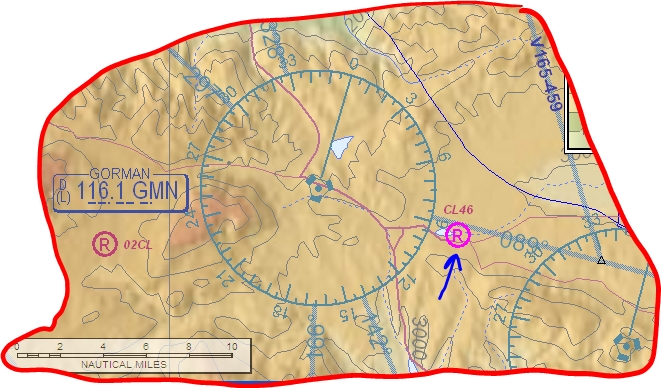
I’ve noticed the odd METAR flag showing up where I thought there was no airport. One place I’ve seen this is near the Gorman Pass in Southern California. When I looked at the chart closely, I noticed a special use airport, Quail Lake Skypark (CL46):
I doubt there actually is some reporting coming from this station, perhaps it is from some other airport with incorrect lat/longs. I know that some passes in Colorado now have ATIS broadcasts, but I’m not aware of anything in California.
I have found a couple of places where there is no airport but I get a weather metar. I am pretty sure that this is a weather reporting station, and even has an identifier, but the identifier doesn’t have any way to show on the MFD. I have also seen these metars on DUATS, etc…
Actually, the flag is on the map page, my trip is 160NM. I do get other weather info on the trip page that are not actual stops on my trip.
Ok, depending on your current setup, the map page should have flags displayed for all the major weather reporting areas. As a matter of fact, if you zoom out to the 750nm range, you will see a map full of METAR flags. I do not have a recent photo of mine, but here is a link to an example on the Avidyne site.
If this is not what you see, and you post a photo of your MFD screen, perhaps one of us can comment further.
Mason:
Thank you for your help. As I mentioned, there is no airport at the location where the flag is located, I know this because I have flown over that area for years, I have my avidyne set-up for IFR and all the declutter is off or is that on. No matter, it’s not that big of a deal. Thanks alot for your help.
I used to farm about 30,000 acres in and around California and we had a number of special use airports for our crop dusters—this may be one of those—pretty crude for GA but fine for ag.